by Patrick McShea
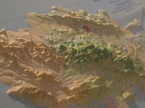
Museum exhibits frequently provide information to help us better understand current headlines. In the case of the devastation Hurricane Matthew recently caused in Haiti, a three dimensional map in the exhibition Population Impact (pictured above) indicates pervasive deforestation across that impoverished Caribbean nation.
The map the depicts the island of Hispaniola. The Dominican Republic encompasses the eastern portion of this mountainous island, and Haiti makes-up the western portion. Shades of deep green, which denote forest cover, crown the highest peaks on the Dominican side of the island. On the Haitian side, the pale brown shades that indicate crop land and pasture stretch from ocean edge to the crests of the highest and steepest ridges.
On the portion of Hispaniola directly in the hurricane ’s path, deforested slopes compounded the destructive power of torrential rain. According to USA Today, less than 2% of Haiti’s land is still forested, making it one of the most deforested countries in the world. The countries steep terrain, clearly seen in our exhibit, also make the country more vulnerable to landslides and mudslides.
Read more about how deforestation left Haiti especially vulnerable to Hurricane
Matthew, and about the hurricane’s devastating effects on the people who live there.
Patrick McShea works in the Education and Visitor Experience department of Carnegie Museum of Natural History. Museum employees are encouraged to blog about their unique experiences and knowledge gained from working at the museum.