by Chase D. Mendenhall
The best way to prevent extinctions is to protect wildlife habitats. In a world where only 13% of the land surface is dedicated to nature reserves, croplands and pastures are playing an increasingly important role in the conversation of biodiversity by providing habitat to some wildlife. Historically, agricultural activities have been pitted against nature reserves—playing the role of the “inhospitable matrix” surrounding nature reserves, which act as “islands” that safeguard biodiversity into the future. In fact, the metaphor of “islands” and “matrix” comes from decades of research studying plants and animals on oceanic islands surrounded by water.
On the mainland, we continue the tradition of largely ignoring the matrix of human-made habitats and the wildlife that use them. A major reason for overlooking human-made habitats is that we develop and use mapping techniques that only value large tracts of wildlife habitat, that are incapable of mapping fine-scale habitats, and that incorrectly classify land use types by confusing forests with croplands and pastures.
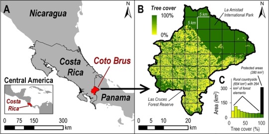
A new study published by the Carnegie Museum of Natural History has attempted to test the classification precision and accuracy of automated tree mapping techniques for identifying wildlife habitat in Costa Rica. In the end, we were surprised to find that two prominent mapping techniques gave distorted estimates of tree cover in deforested areas and that these distortions are potentially leading to poor decision making beyond the borders of nature reserves. We recommend conservation scientists interested in quantifying wildlife habitats embedded in croplands and pastures to consider modest techniques of digitizing habitats by hand using Google Earth. We also identify lots of room for developing new technologies using satellites, citizen science, and drones to solve the problem of counting up wildlife habitats, big and small.
The full study is available as a PDF: Improving tree cover estimates for fine-scale landscape ecology.
Chase Mendenhall is Assistant Curator of Birds, Ecology, and Conservation at Carnegie Museum of Natural History. Museum employees are encouraged to blog about their unique experiences and knowledge gained from working at the museum.