by Max Winn and Andrea Kautz
Since the passing of Act 54 in 1994, Pennsylvania requires a review of all subsidence impacts related to underground coal mining every five years. Subsidence occurs when land at the surface collapses down into a cavity created by removing a layer of coal. This can affect structures, roads, water wells/springs, streams, ponds, and wetlands. It can also induce landslides.
Powdermill scientists are currently part of the oversight team for the 2013-2018 review, and are using GIS technology to calculate and assess the impacts that mines have specifically on streams and wetlands. Most subsidence impacts occur over “long wall” mines, where enormous panels of coal are removed. “Room and pillar” mines leave pillars of coal to support the roof of the mine, which generally prevents subsidence, but impacts may still occur.
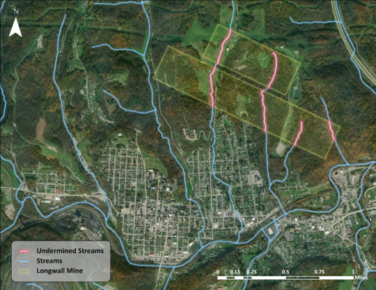
Take a look at this aerial imagery of a portion of a longwall mine, that shows just how much area the panels cover and the streams that are undermined. The larger panel is over a mile long! Using GIS, we can calculate how much of the undermined streams are impacted by either flow loss or pooling. Flow loss is experienced when the earth fractures and the water is lost below the surface. Pooling occurs when water collects in a depression caused by subsidence and can no longer flow downstream.

When stream impacts occur in Pennsylvania, the coal companies are required to mitigate the damage to return the stream to its previous state. Because you can generally predict where subsidence impacts are going to occur before mining, pre-mining surveys are done to determine the health of the streams initially. The survey determines normal flow rates throughout the year, and also describes the community of aquatic macroinvertebrates that live in the stream. Based on what types of insects and other invertebrates are found during the survey, the stream is given a score based on how healthy it is. These data are used to compare to post-mining surveys that occur after attempts to mitigate have been completed. If the scores are comparable, the stream is considered repaired, but if not, the company is required to take further mitigative action.
Experts from the Carnegie Museum of Natural History and Powdermill Nature Reserve are working with regulatory agencies and mining companies to ensure that our natural environment is passed on to the next generation in a healthy condition.
Max Winn is a GIS Technician and Andrea Kautz is a Research Entomologist at Carnegie Museum of Natural History’s Powdermill Nature Reserve. Museum employees are encouraged to blog about their unique experiences and knowledge gained from working at the museum.
