• Skip to primary navigation
  • Skip to main content
  • Skip to primary sidebar

Carnegie Museum of Natural History

One of the Four Carnegie Museums of Pittsburgh

  • Visit
    • Buy Tickets
    • Visitor Information
    • Exhibitions
    • Events
    • Dining at the Museum
    • Celebrate at the Museum
    • Powdermill Nature Reserve
    • Event Venue Rental
  • Learn
    • Field Trips
    • Educator Information
    • Programs at the Museum
    • Bring the Museum to You
    • Guided Programs FAQ
    • Programs Online
    • Climate and Rural Systems Partnership
    • We Are Nature Podcast
  • Research
    • Scientific Sections
    • Science Stories
    • Science Videos
    • Senior Science & Research Staff
    • Museum Library
    • Science Seminars
    • Scientific Publications
    • Specimen and Artifact Identification
  • About
    • Mission & Commitments
    • Directors Team
    • Museum History
  • Tickets
  • Give
  • Shop

research

December 31, 2018 by wpengine

From Metes and Bounds to GPS: Part 2

By James Whitacre

In my last post I talked about how surveyors and cartographers used chains and compasses to survey the land. They also used the system of metes and bounds to describe the data they collected, typically for land ownership purposes. At the GIS Lab at Powdermill Nature Reserve, we no longer use these techniques of old when mapping research data in the field. But with today’s advances in technology, we use much different methods and tools to collect research data.

The primary tool used today for collecting data in the field is a GPS receiver, as you might have guessed. At Powdermill, we use these devices to quickly and efficiently record latitude, longitude, and altitude. We can also couple GPS receivers with mobile apps to help us collect other non-spatial data.

To learn more about projects that use mobile apps and GPS, I recommend checking out the BirdSafe Pittsburgh program and our effort to map plastic waste.

However, you may be wondering, what exactly is GPS…and what does it actually stand for? The Global Positioning System (GPS) is operated by the US Air Force and has been around since 1978. It is a world-wide constellation of over 30 satellites that are constantly in orbit around the earth. With just four satellites in view, the location of the GPS device can be determined by using a process called trilateration, which measures the distances between multiple satellites and the device on the ground (I’m not going to get into the technical math…). GPS is also just one of a few other global navigation satellite systems (GNSS), as Russia, China, and the European Union all have operational systems as well. Many GPS devices utilize all GNSS systems.

There are many different types of GPS devices and they are generally categorized into three accuracy levels: recreational grade (accurate from 3 to within 10 meters), mapping grade (0.5 to 3 meters), or survey grade (1 millimeter to 0.5 meters). If your smartphone has GPS on it, as most do, that is considered a recreational grade GPS device. Other recreational GPS devices, such as Garmin devices, are fairly affordable and can be found at sporting goods stores. More sophisticated GPS devices for mapping and surveying are not typically found in stores and must be ordered from specialty vendors.

GIS lab mapping tools including GPS

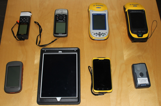
The above image shows the different devices the GIS Lab has used over the years. At Powdermill, we use mapping grade GPS devices most often, as represented by the four devices on the right in the image above, but we also use recreational GPS devices and GPS-enabled mobile devices, which are the four devices on the left. We no longer use the top row of devices as the devices on the bottom row are newer technology that vastly outperform the older devices. The need for survey grade GPS devices is not typically needed for research at Powdermill, as one to three meters of accuracy is usually good enough for most ecological and field biology research.

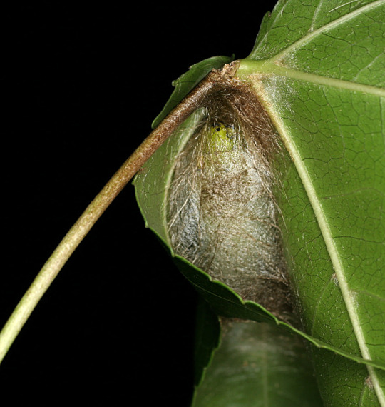
By collecting research data with geographic information collected from GPS, we can analyze ecological phenomena in space, which allows us to discover much more about plant and animal communities. For example, we have used GPS to collect where trees are in addition to the species and size of the trunk. When we analyzed the distribution of our trees, we learned that red maples tend to grow on south facing slopes, while sugar maples tend to grow on north facing slopes. This information could impact future decisions for our forest management. Therefore, it is essential that we think spatially about our research!

James Whitacre is the GIS Research Scientist for Carnegie Museum of Natural History, where he primarily manages the GIS Lab at Powdermill Nature Reserve, the Museum’s environmental research center. Museum employees are encouraged to blog about their unique experiences and knowledge gained from working at the museum.

Filed Under: Blog Tagged With: GIS lab, GIS Research, James Whitacre, Powdermill Nature Reserve, research

July 27, 2018 by wpengine

The Very Hungry Promethea Caterpillars

by Vanessa Verdecia

promethea moth eggs

These Promethea Moth (Callosamia promethea) eggs were laid in clusters by a single female parent.  When the caterpillars first hatched they measured approximately 3mm in length and as the caterpillars grew, they shed their skin and molted through a series of stages referred to as instars.  Each one of these instars varies in appearance.  Early instars are gregarious and remain together on the underside of the leaves.  

promethea moth caterpillars

In the earlier instars the Promethea Moth caterpillars have a black and yellow banded appearance.  In contrast to these earlier stages, the body of the last instar caterpillars are pale green and they are recognized by the protruding, bright red knobs that are located on the thoracic region as well as the yellow knob found on the eighth abdominal segment.  The final instar caterpillars in this culture measured up to 4.5cm in length in a resting position, but they can measure up to 6cm when active and stretched out.

promethea moth caterpillar

The Promethea Moth is a member of the family Saturniidae, a group known as the Giant Silkworm moths. In this group of moths, the mouth parts are reduced and the digestive tract is absent, which means they do not feed as adults.  Most caterpillar species are big eaters, but in families like Saturniidae, the adult moths rely heavily on all the energy stored while eating in the larval stages.

Raising caterpillars in the lab is a labor of love.  Caterpillars depend on having fresh food and a clean environment that is created by housing the live caterpillars in plastic chambers that help preserve the moisture in the leaves.  This culture was reared on sweet gum, but Promethea Moth caterpillars will feed on many different trees.  The caterpillars hatched on 8-June-2018 and some of the specimens in the final instars were seen spinning their cocoons on 17-July-2018.

caterpillars on sweet gum

The caterpillars produce silk on a leaf and the petiole and spin a cocoon with the leaf wrapped around it. After the caterpillars spin their cocoons, they will enter the pupal stage and overwinter until the late spring or early summer of 2019, however, a partial second generation in the summer is known to occur in Pennsylvania.  Cocoons attached to the hostplant by the silk can be seen in the winter when all the other leaves have fallen.

cocoon

Vanessa Verdecia is a collection assistant in the museum’s Invertebrate Zoology Section. Museum employees are encouraged to blog about their unique experiences and knowledge gained from working at the museum.

Filed Under: Blog Tagged With: caterpillars, Invertebrate Zoology, moths, nature, research, Vanessa Verdecia

July 10, 2018 by wpengine

Adult Flycatcher

Adult Flycatcher

This adult Flycatcher undergoes the pre-basic molt of the wintering grounds. These adults can be readily identified by their white bars and wear on the feather tips.


Powdermill Nature Reserve’s avian research center is part of Carnegie Museum of Natural History’s biological research station in Rector, Pennsylvania.  The research center operates a bird banding station, conducts bioacoustical research, and performs flight tunnel analysis with the goal of reducing window collisions.


Filed Under: Blog Tagged With: avian research, bird banding, birding, Birds, nature, parc, Powdermill, Powdermill Nature Reserve, research

July 10, 2018 by wpengine

Acadian Flycatcher

acadian flycatcher

This Flycatcher has a pale yellow mouth lining.


Powdermill Nature Reserve’s avian research center is part of Carnegie Museum of Natural History’s biological research station in Rector, Pennsylvania.  The research center operates a bird banding station, conducts bioacoustical research, and performs flight tunnel analysis with the goal of reducing window collisions.


Filed Under: Blog Tagged With: avian research, avian research center, bird banding, Birds, nature, parc, Powdermill, Powdermill Nature Reserve, research

October 24, 2016 by wpengine

Fall Bird Banding at Powdermill

bird banding at Powdermill Nature Reserve

Fall is an exciting and busy time for our avian researchers at Powdermill Nature Reserve, Carnegie Museum of Natural History’s environmental research center in Rector Pennsylvania.

As birds migrate south, thousands fly through Powdermill, where they are identified, banded, and studied before they continue their long journey to their winter nesting grounds.

Researchers band anything from worm-eating Warblers to brightly colored purple finches in their nets each year.

This fall alone, more than 4,000 birds representing 150+ species have been studied and banded since September. Researchers catch the birds in specially designed mist nets that are cast each morning before dawn. Caught birds are carefully transported to a banding station, where they are identified, measured, and given a small band issued through the US Geological Survey.  Bands provide information for other researchers and don’t affect the birds flight, nesting, or eating habits.

Above all else, the well being of every bird is Powdermill’s top priority at all times. The entire banding process takes less than a minute, and the vast majority of birds are actually quite calm during their short visit at the banding station.

But why band birds at all?

The fundamental goal of bird banding has always been to record the age, sex, wing length, fat deposits, and body mass of captured species as a way of monitoring, year to year, how avian populations are faring in the wild.

Banding gives us insight into many things like the life cycles and longevity of birds, habitat use, and how disease and environmental toxins are affecting wild bird populations.

Want to learn more? You can see monthly and annual banding summaries online or follow Powdermill Nature Reserve on Facebook for weekly updates and stunning pictures.

Filed Under: Blog Tagged With: avian research, bird banding, Birds, nature, parc, Powdermill, research

July 7, 2016 by wpengine

Researchers chase snails on Santa Rosa Island, California

Pearce collecting snails at Carrington Point
Pearce collecting snails at Carrington Point on Santa Rosa Island, California. San Miguel Island is visible in the distance. (Photo by Charles Drost.)

by Tim Pearce

Islands often contain peculiar species, including some that are endemic (found only there). Tim Pearce, Assistant Curator of the Section of Mollusks at Carnegie Museum of Natural History, spent five days with two other researchers surveying the land snails of Santa Rosa Island, one of the California Channel Islands. This survey is part of a larger project, funded by the National Park Service, to understand the land snails of the California Borderlands.

The researchers braved spiny vegetation and strong winds (sometimes pebbles became airborne) to find at least three new land snail records for the island among the dozen or so species they found. Several species found are endemic to the California Channel Islands. Further scrutiny of the finds will reveal whether any species are endemic to just Santa Rosa Island or possibly new to science.

Snails were often surprisingly difficult to find, which might reflect recent disturbance history of the island. The last of the large non-native mammals (goats, sheep, pigs, cattle, deer, and elk) were removed from the island in 2013. These animals can impact snail populations through trampling and more importantly by eating vegetation, changing it from forest to grassland. This study provides a baseline to inform future investigation of how snail faunas recover after disturbance.


Timothy A. Pearce, PhD, is the head of the mollusks section at Carnegie Museum of Natural History. Museum employees are encouraged to blog about their unique experiences and knowledge gained from working at the museum.


Filed Under: Blog Tagged With: mollusks, research, snails, Tim Pearce

  • Page 1
  • Page 2
  • Go to Next Page »

sidebar

About

  • Mission & Commitments
  • Directors Team
  • Museum History

Get Involved

  • Volunteer
  • Membership
  • Carnegie Discoverers
  • Donate
  • Employment
  • Events

Bring a Group

  • Groups of 10 or More
  • Birthday Parties at the Museum
  • Field Trips

Powdermill

  • Powdermill Nature Reserve
  • Powdermill Field Trips
  • Powdermill Staff
  • Research at Powdermill

More Information

  • Image Permission Requests
  • Science Stories
  • Accessibility
  • Shopping Cart
  • Contact
  • Visitor Policies
One of the Four Carnegie Museums | © Carnegie Institute | Privacy Policy | Terms of Use | Accessibility
Rad works here logo