• Skip to primary navigation
  • Skip to main content
  • Skip to primary sidebar

Carnegie Museum of Natural History

One of the Four Carnegie Museums of Pittsburgh

  • Visit
    • Buy Tickets
    • Visitor Information
    • Exhibitions
    • Events
    • Dining at the Museum
    • Celebrate at the Museum
    • Powdermill Nature Reserve
    • Event Venue Rental
    • Gift Cards
  • Learn
    • Field Trips
    • Educator Information
    • Programs at the Museum
    • Bring the Museum to You
    • Guided Programs FAQ
    • Programs Online
    • Climate and Rural Systems Partnership
  • Research
    • Scientific Sections
    • Science Stories
    • Science Videos
    • Senior Science & Research Staff
    • Museum Library
    • Science Seminars
    • Scientific Publications
    • Specimen and Artifact Identification
  • About
    • Mission & Commitments
    • Directors Team
    • Museum History
  • Tickets
  • Give
  • Shop

We Are Nature 2

May 5, 2021 by wpengine

Understanding Fossil Fuels through Carnegie Museums’ Exhibits

by Albert D. Kollar, Collection Manager, with assistance from Suzanne Mills, Collection Assistant, and Joann Wilson, Volunteer Section of Invertebrate Paleontology

The exhibits of Carnegie Museum of Natural History and Carnegie Museum of Art are ideal for a multidisciplinary study of fossil fuels in Pennsylvania and beyond. Such a study must properly begin with some historical background about the landmark Oakland building that houses both museums, as well as some background information about fossil fuels.

When the Carnegie Library of Pittsburgh opened in 1895, the architects, Longfellow, Alden, and Harlow incorporated roof skylights for maximum daytime lighting in the Italian Renaissance designed building1. Nighttime activities were illuminated by interior gas lighting fixtures, possibly supplied by the Murrysville gas field, which began production in 1878.  With the opening of the Carnegie Institute Extension in 1907, the Bellefield Boiler Plant was built in Junction Hollow to supply in-house steam heat and electricity from bituminous coal1. From the 1970’s, coal and natural gas had been used to heat the boilers that supply heat to the Oakland Campus, Phipps, the University of Pittsburgh and the Oakland hospitals.  In 2009 coal was eliminated as a fuel source.  Electricity on the other hand, is supplied through Talen Energy from multiple sources (coal, gas, and renewal energy sources). For the future, Carnegie Museums of Pittsburgh plans to receive its electricity from renewable solar energy via Talen Energy2.

What are Fossil Fuels?

Coal, oil, and natural gas (methane), known collectively as fossil fuels, are sources of energy derived from the remains of ancient life forms that usually  are found preserved in coal rock, black shale, and sandstone.

Exhibit called "What's a Fossil Fuel?" Fossil fuels on display are labeled clockwise from the top as follows: peat, bituminous coal, anthracite coal, sub-bituminous coal, oil glass tubes, lignite.
Figure 1.

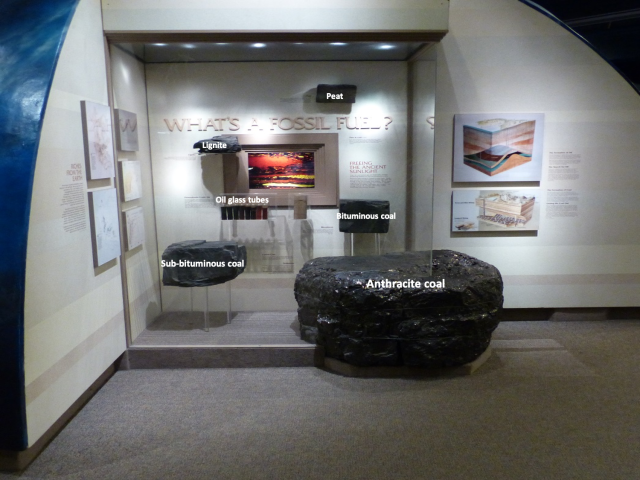
Coal is a rock. The coalification process starts from a thick accumulation of plant material in reducing environments where the organic matter does not decay completely. This deposit of plant residue that thrives in freshwater swamps at high latitudes forms peat, an early stage or rank in the development of coal. With the burial of peat over geologic time and a low temperature form of metamorphism produces a progression of the maturity or “rank” of the organic deposits that form the coal ranks of lignite, sub-bituminous, bituminous, and anthracite)3 (Fig. 1). The Pennsylvanian Period was named for the rocks and coals of southwestern Pennsylvania that formed more than 300 million years ago.

Oil and natural gas, collectively known as hydrocarbons, were forming in the Devonian rocks of Pennsylvania between 360 and 390 million years ago. These hydrocarbon deposits or kerogens are made of millions of generations of marine plankton and animal remains that accumulated in a restricted anoxia ocean basin that extended from southern New York, through western Pennsylvania, northern West Virginia to eastern Kentucky4. The thick layers of sediment formed black shales or mud rocks such as the Marcellus Shale. Black shales are rich in oil and gas and are called source rocks. Sandstones such as the Oriskany Sandstone that is older than the Marcellus Shale is a reservoir rock. An amorphous mass of organic matter or kerogen undergo complex geochemical reshuffling of the hydrocarbon molecules first with burial then by thermal “cracking” as heat and pressure through the geologic process of metamorphism over millions of years transform kerogen into modern day fossil fuels4.

Fossil Fuels in Modern Society

As commodities converted to fuels for our modern world, these resources account for 80% of today’s energy consumption in the United States5. All three fossil fuels, in furnaces of vastly different design, have been used to directly heat homes, schools, workplaces, and other structures. In power plants, all three have been used for generating electricity for lighting, charging mobile phones, and powering computers, home appliances, and all manner of industrial machines. In the United States, , coal became the country’s primary energy source in the late 1880s, displacing the forest-destroying practice of burning wood. It ceded the top spot to petroleum in 1950 but enjoyed a late-20th-century renaissance as the primary fuel for power plants5. Coal now generates approximately 11% of our country’s supply down from 48% just 20 years ago. Natural gas is currently used to generate approximately 35% of US electricity supplanting the use of coal6. While petroleum is less than1%6.

Transportation accounts for approximately 37% of total energy consumption. Coal played a historic role in powering railroads, and both compressed natural gas and batteries (charged with electricity generated from various sources) are of growing importance, however, refined oil products currently power 91% of the transportation sector6.

Newspaper clipping from The Rodnen & Otamatea Times dated Wednesday, August 14, 1912. The story shown is as follows: Science Notes and News. Coal Consumption Affecting Climate. The furnaces of the world are now burning about 2,000,000,000 tons of coal a year. When this is burned, uniting with oxygen, it adds about 7,000,000,000 tons of carbon dioxide to the atmosphere yearly. This tends to make the air a more effective blanket for the earth and to raise its temperature. The effect may be considerable in a few centuries.
Figure 2.

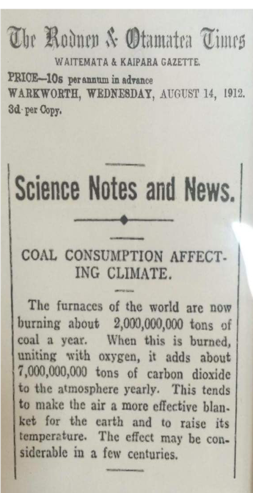
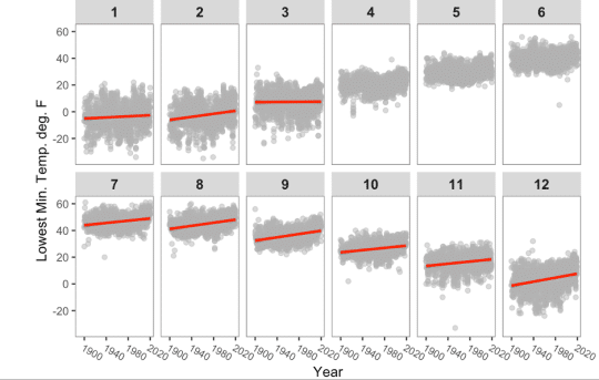
In the early 20th century, scientists warned about how the burning of coal could create global warming in future centuries by raising the level of carbon dioxide, a greenhouse or heat-holding, gas, in the atmosphere. (Fig. 2 ). It took less than a century for evidence to mount of climate change associated with the burning of fossil fuels, the clearing of forests associated with industrial scale livestock production, and from waste management and other routine processes of modern life. In recent decades headlines have routinely proclaimed the risks of a warming planet, including damage to terrestrial ecosystems, the oceans, and a rise in sea level7.

Fossil Fuels and Museum Geology Displays

When architects Frank E. Alden and Alfred B. Harlow designed the Carnegie Institute Extension (1907), they incorporated Andrew Carnegie’s vision to create an introduction hall to the museum named Physics, Geology and Mineralogy8. This hall (the forerunner to Benedum Hall of Geology) was intended to introduce Pittsburghers to the regional natural history subjects of geology, paleontology, and economic geology (fossil fuels)9.

Exhibit in Benedum Hall of Geology with fake trees in the foreground and a swamp diorama in the background.
Figure 3.

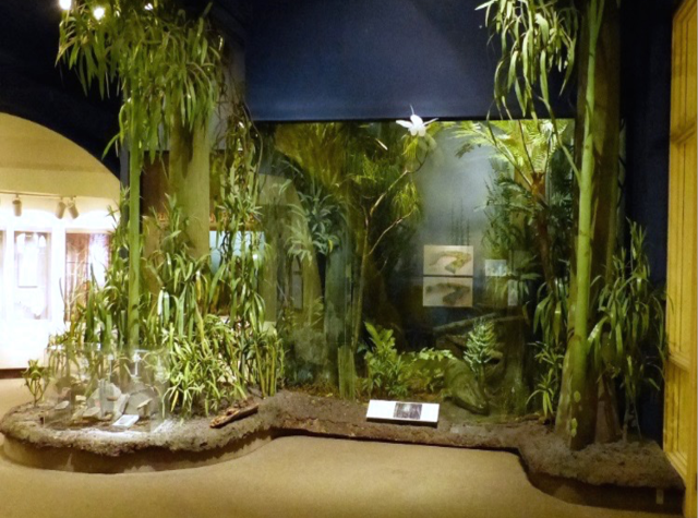
In the 1940s, the 300-million-year-old Pennsylvanian age coal forest diorama was installed in a corner space of what is now part of the Benedum Hall of Geology (Fig. 3). Because coal converted to coke is a vital ingredient in steel production, this three-dimensional depiction of the conditions under which Pittsburgh’s economically important coal deposits formed was (and remains) an important public asset.

Exhibit labeled Pennsylvanian Marine Life. Below the sign is a diorama designed to look like an aquarium.
Figure 4.

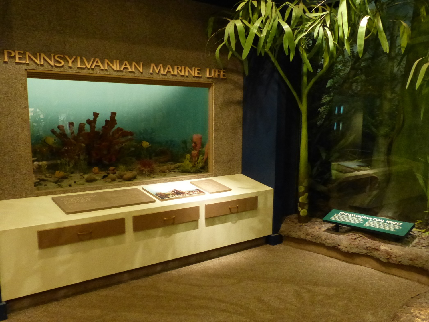
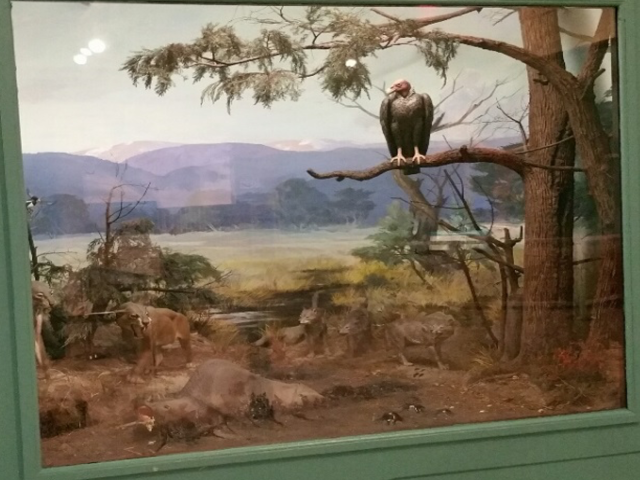
In 1965, as part of an overall plan to bring more of the natural history museum’s fossil collection to the public, Paleozoic Hall opened with funding from the Richard King Mellon Foundation10. This exhibition featured nine dioramas that recreate the ancient environments through 290 million years of Earth history. Sadly, only one of the nine units remains on display, the diorama depicting the Pennsylvanian age marine seaway (Fig. 4 ), in the Benedum Hall of Geology.

Since the Benedum Hall of Geology opened to the public in 1988 the exhibition has featured an economic geology component with displays explaining differences between coal ranks Lignite coal to anthracite coal, and a variety of Pennsylvania’s crude oils and lubricants processed from the historic well Edwin Drake drilled in Titusville in 1859 (Fig. 1 )11.

Benedum Hall of Geology strata wall. Shows different colors of rock stratigraphy from left to right: tan, blue-grey, maroon, beige, dark gray, olive green.
Figure 5.

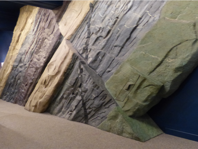
Today, the Hall’s “strata wall,” a towering depiction of some of the rock layers found thousands of feet below western Pennsylvania, is in my opinion, an under-utilized display in terms of conveying information about fossil fuels. Although the wall is not currently documented with any geologic information, minor changes might allow visitors to use the lens of rock strata  to better understand historical events such as the Drake Well, and economically important geologic reservoirs such as the Marcellus Shale (the second largest gas deposit in the United States), the natural gas storage reservoir of the Oriskany Sandstone, and the gas and liquid condensate (ethane) extracted from the Utica Formation (Ordovician Age) for making plastic products at the Shell Cracker Plant in Beaver County, PA (Fig. 5 ).

Exhibit case labeled Holzmaden. A blue arrow points to a crinoid fossil.
Figure 6.

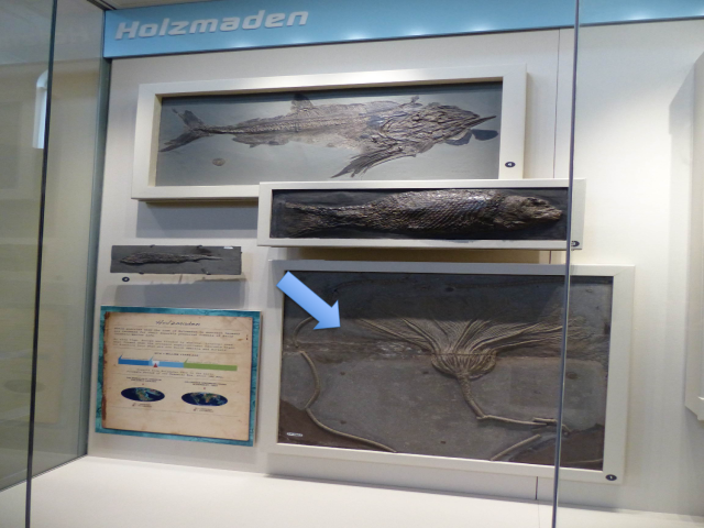
Elsewhere in the museum, visitors can learn more about the topic of fossil fuels at several other locations. At the Holzmaden fossil exhibit in Dinosaurs in Their Time, there is a large fossil crinoid preserved in a dark gray limestone of Jurassic age, that represents a  reservoir of crude oil in Germany (Fig. 6). At the mini diorama of the La Brea tar pits, oil seeps from natural fractures from an approximately six-million-year-old rock of Miocene age,  to the unconsolidated surface sediment in what is now part of the City of Los Angeles (Fig. 7).

La Brea tar pits diorama. A vulture sits on a tree above the tar pits.
Figure 7.

Looking for Fossil Fuel Evidence in Art

In 2018, I reviewed 58 landscape paintings and the John White Alexander wall murals on the first and second floors of the Grand Staircase within Carnegie Museum of Art (CMOA) galleries to look for artistic documentation of what I interpreted to be causes for climate change based on the science. I found many examples based on the use of coal as a fossil fuel for power and coking in steel mills and the natural formation of bio-methane as portrayed in ecosystem landscapes of  the industrial age of the middle 19th and early 20th century12.

Collage of coal landscapes. Clockwise from top right: Waterloo Bridge, London, Claude Monet c. 1903; The Great Bridge, Rouen (Le Grand Pont, Rouen), Camille Pissarro, c. 1896; Pittsburgh Fifty Years Ago from the Salt Works on Saw Mill Run, Russell Smith, c. 1884; The Crowning of Labor Murals, John White Alexander, c. 1905 - 1908; The Coal Carrier, David Gilmore Blyth, c. 1854 - 1858
Figure 8.

Collage of five illustrations of steel mills
Figure 9.

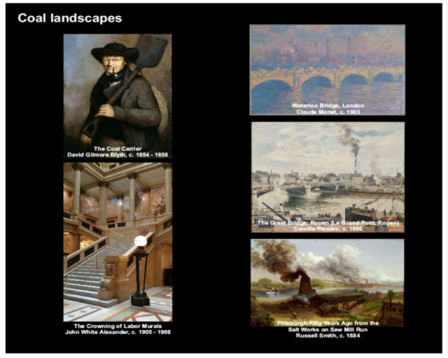
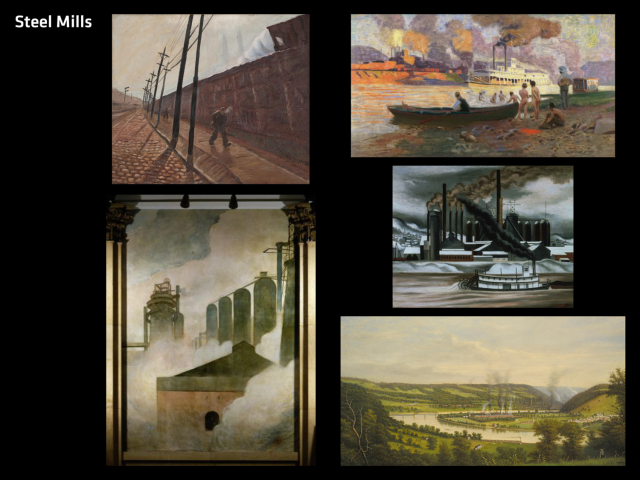
Searching for the CMOA landscapes paintings takes a little patience, but the visitor is rewarded by taking a new look at some of the art museum’s classic paintings (Fig. 8 and 9).

Three historic landmark signs. On left: First Mining of Pittsburgh Coal. This State's bituminous coal industry was born about 1760 on Coal Hill, now Mt. Washington. Here the Pittsburgh coal bed was mined to supply Fort Pitt. This was eventually to be judged the most valuable individual mineral deposit in the U.S. Sign on the top right: Drake Well Park. On this site Col. Edwin Drake struck oil Aug. 27, 1859; the birth of the petroleum industry. Sign on the bottom right: Murrysville Gas Well: First gas well in county and one of the world's most productive. Drilled, 1878. Caught fire in 1881, burning for years with tremendous roar and brilliance. Later was controlled and piped to Pittsburgh. Site lies 500 yards S.E. near railroad.
Figure 10.

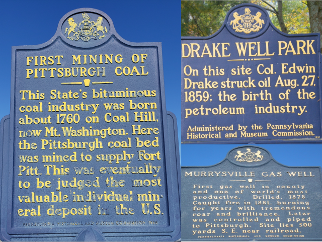
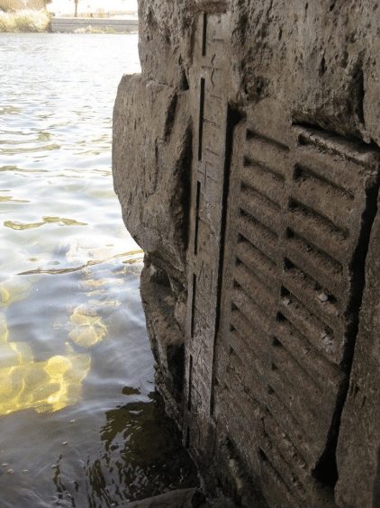
Within day trip visiting distance of Carnegie Museums are historic plaques highlighting the discovery of coal on Mount Washington, natural gas in Murrysville, and oil in Titusville, Pennsylvania. (Fig. 10). At all three stops you’ll have a better understanding of the significance if you begin your investigation of fossil fuels at Carnegie Museums.

Albert D. Kollar is the Collection Manager for the Section of Invertebrate Paleontology. Suzanne Mills is the Collection Assistant and Joann Wilson is a volunteer Section of Invertebrate Paleontology. Museum employees are encouraged to blog about their unique experiences and knowledge gained from working at the museum.

References

  1. Kollar, A.D. 2020. CMP Travel Program and Section of Invertebrate Paleontology promotes the 125th Anniversary of the Carnegie Library of Pittsburgh with an outdoor walking tour. https://carnegiemnh.org/125th-anniversary-carnegie-library-of-pittsburgh-outdoor-walking-tour/
  2. Personal communications Anthony J. Young, Vice President (FP&O) Carnegie Museums of Pittsburgh.
  3. Brezinski, D. K. and C K. Brezinski. 2014. Geology of Pennsylvania’s Coal. PAlS Publication Number 18.
  4. Geology of the Marcellus Shale. 2011. Brezinski, D.K., D. A. Billman, J.A. Harper, and A.D. Kollar. PAlS Publication 11.
  5. https://www.bloomberg.com/news/articles/2021-05-03/coal-consumption-in-the-u-s-declines-as-natural-gas-solar-wind-energy-rise
  6. United States Energy Agency (EIA) 2019.
  7. Bill Gates. 2021. How to Avoid A Climate Disaster.
  8. Kollar et al. 2020. Carnegie Institute Extension Connemara Marble: Cross-Atlantic Connections Between Western Ireland and Gilded Age Architecture in Pittsburgh, Pennsylvania. ACM, 86, 207-253.
  9. Dawson, M. R. 1988. Benedum Hall of Geology. Carnegie Magazine, 12-18.
  10. Eller, E. R. 1965. Paleozoic Hall. Carnegie Magazine, 255-338.
  11. Harper and Dawson 1992. Benedum Hall-A Celebration of Geology. Pennsylvania Geology, 23, 12-15.
  12. Kollar et al. 2018. Geology of the Landscape Paintings at the Carnegie Museum of Art, a Reflection of the “Anthropocene” 1860-2017. Geological Society of America, Abstracts with Programs, v. 49, 243.

Related Content

The Story of Oil in Western Pennsylvania: What, How, and Why?

The Giant Eurypterid Trackway: A Great Fossil Discovery on Display

Cities Are Not Biological Deserts

Carnegie Museum of Natural History Blog Citation Information

Blog author: Kollar, Albert
Publication date: May 5, 2021

Share this post!

  • Share on Twitter Share on Twitter
  • Share on Facebook Share on Facebook
  • Share on Pinterest Share on Pinterest
  • Share on LinkedIn Share on LinkedIn
  • Share on Reddit Share on Reddit
  • Share via Email Share via Email

Filed Under: Blog Tagged With: Albert Kollar, Benedum Hall of Geology, invertebrate paleontology, Joann Wilson, Suzanne Mills, We Are Nature 2

April 7, 2021 by wpengine

Cities are Not Biological Deserts

by Nicole Heller

Cities are increasingly important in organizing the experience of people and their interactions with nature. In 1950 there were 2.5 billion people on Earth and 30% lived in cities. Today, there are 7.5 billion people and 55% live in cities. By 2050, there will be an estimated 9.5 billion and 68% will live in cities.

Generally, cities are not good places for other critters to live. The abundance of pavement, buildings, traffic, pollution, pesticides, herbicides, and other hazards make cities really hard places for plants and animals to survive and breed. From a conservation science perspective, cities have long been considered dead spaces, or biological deserts. But more recently researchers are paying more attention to nature in cities. One reason for their interest involves people’s need for nature. Study after study confirms the basic biophilia hypothesis, that people want to associate with nature; they are happier and healthier when they are near plants and animals in their daily lives.

Berlin is recognized as a city that works for people and biodiversity due to its high percentage of green space, variety of habitats, and thoughtful regional planning. Photo by Filipe Varela on Unsplash.

Cities have also drawn the attention of researchers because of some really exciting things are happening within their limits, such as growing populations of peregrine falcons , sightings of rare birds using cities parks during annual migrations, and even discoveries of new species not previously known to science. While cities are overall negative for biodiversity, recent research findings raise important questions: Can human cities be good for non-humans too? Can urban wildlife include a broader spectrum of creatures beyond the common city-adapted species like European sparrows, pigeons, and black rats? What about species special or unique to the regions in which cities are located? How can we make cities work for biodiversity?

A few years ago I posed these questions along with colleagues from the Resilient Landscape program at the San Francisco Estuary Institute. We wanted to learn if there were general lessons that could be distilled from recent and ongoing research projects about what kinds of species can benefit from cities and if so how might city planners utilize this information to prioritize actions that would help cities contribute positively to the resilience of regional biodiversity, or at least do more to diminish the negative impacts.

Earlier this year, some of our findings were published open source in the journal Bioscience, The Biological Deserts Fallacy: Cities in Their Landscapes Contribute More than We Think to Regional Biodiversity, by Erica N Spotswood, Erin E Beller, Robin Grossinger, J Letitia Grenier, Nicole E Heller, Myla F J Aronson.

The study, which includes citations from dozens of regional research projects around the world, identifies five pathways by which cities can help regional biodiversity. “Cities can benefit some species by releasing them from threats in the larger landscape, increasing regional habitat heterogeneity, acting as migratory stopovers, enhancing regional genetic diversity and providing selective forces for species to adapt to future conditions under climate change (e.g., a phenomenon we are calling preadapting species to climate change), and enabling and bolstering public engage­ment and stewardship.”

Each of these pathways is described in greater detail in the study. Four categories of species commonly utilize urban habitat, with varying degrees of success, and the study explores examples of how specific species in specific places demonstrate these five pathways.

screen grab of a figure from a paper with birds and flowers

Overall, the role of cities in supporting landscape-scale biodiversity is an understudied area of research. As cities continue to grow in number and size, human populations rise, and climate change continues, paying attention to the experience of other critters, and how we can make space for them to survive and thrive in anthropogenic habitats, will be more important than ever. This research identifies opportunities to reconcile cities with biodiversity. Opportunities exist to learn more about the unique resources that cities can provide, which specific types of species can take advantage of these resources, and how this information can be incorporated into city plans for parks and green spaces. The San Francisco Estuary Institute has begun this applied work in their report Making Nature’s City, which presents a science-based framework for increasing biodiversity in cities.

What excites me are possibilities if we really try. For the most part cities have been developed with little or no concern for biodiversity. Often people think that humans and nature just can’t coexist. What if city planners and conservation professionals start applying these lessons from ecology more broadly and work together with citizens to deliberately steward biodiversity in cities? How abundant and rich with diverse life could cities become? How happy would that make humans? I wonder. And I am hopeful.

If you are interested in urban nature, you can help to measure its diversity by participating in the museum’s upcoming City Nature Challenge. You never know what you may find in our city. Our combined observations, coupled with the museum’s collections and records, will provide important benchmarks to help track how local species are doing as the region keeps growing and changing in the 21st century.

Full Article Citation

The Biological Deserts Fallacy: Cities in Their Landscapes Contribute More than We Think to Regional Biodiversity By ERICA N. SPOTSWOOD , ERIN E. BELLER, ROBIN GROSSINGER, J. LETITIA GRENIER, NICOLE E. HELLER, AND MYLA F. J. ARONSON BioScience, Volume 71, Issue 2, February 2021, Pages 148–160, https://doi.org/10.1093/biosci/biaa155

Nicole Heller is Curator of Anthropocene Studies at the Carnegie Museum of Natural History. Museum employees are encouraged to blog about their unique experiences working at the museum.

Related Content

Teaching About Local Wildlife with the City Nature Challenge

Air Quality and Urban Gardening

Introducing the Anthropocene Living Room

Carnegie Museum of Natural History Blog Citation Information

Blog author: Heller, Nicole
Publication date: April 7, 2021

Share this post!

  • Share on Twitter Share on Twitter
  • Share on Facebook Share on Facebook
  • Share on Pinterest Share on Pinterest
  • Share on LinkedIn Share on LinkedIn
  • Share on Reddit Share on Reddit
  • Share via Email Share via Email

Share this post!

  • Share on Twitter Share on Twitter
  • Share on Facebook Share on Facebook
  • Share on Pinterest Share on Pinterest
  • Share on LinkedIn Share on LinkedIn
  • Share on Reddit Share on Reddit
  • Share via Email Share via Email

Filed Under: Blog Tagged With: Anthropocene, City Nature Challenge, Nicole Heller, Science News, We Are Nature 2

November 10, 2020 by wpengine

What Does Climate Change Mean for Western PA Farmers?

Agriculture is many things when it comes to climate change: a source of heat trapping gases, a casualty of extreme weather events, and part of the solution. At Carnegie Museum of Natural History, we’re working with rural communities in western Pennsylvania to talk about climate change in conversations that connect the dots between agriculture as a source of emissions, a sector of vulnerability, and an under explored reservoir of much needed solutions. This work is happening through the Climate and Rural System Partnership (CRSP, which we pronounce “crisp”), a National Science Foundation-funded program involving three CMNH components (the Education Department, the Section for Anthropocene Studies, and Powdermill Nature Reserve), partner researchers at the University of Pittsburgh’s Center for Learning Out of School Environments, and the Mercer County Conservation District. In CRSP, we are using methods of co-production and co-design to develop climate change science and communication resources with our community partners that are relevant to the lived experiences and concerns of those partners’ and their audiences.

How is climate change impacting farmers in western PA? What would help them to make adaptive planning decisions? What mitigation actions are most attractive to western PA farmers and will best help to sustain livelihoods into the future? Are Western PA farmers already, or interested in becoming, climate champions–leading their community in mitigating and adapting to climate change on their farm?  How can the museum help? These are some of the questions we are exploring in CRSP.

Working alongside local livestock and row crop farmers, Penn State agriculture extension educators, and representatives of the Natural Resource Conservation Service (the agency formerly known as the U.S. Soil and Conservation Service), and the Mercer County Conservation District (a CRSP network hub), I have the privilege of exploring these issues and co-producing useful communication resources. Co-production is an iterative collaboration involving diverse perspectives to produce locally relevant knowledge and solutions (Norstrom et al 2020, Meadows 2015). Instead of scientists being the sole creators of new knowledge, in co-production all are creators of new knowledge.

Mercer County Conservation District, CRSP partners, and other Mercer area farmers at a soil health workshop and demonstration in a no-till soybean field at Goddard State Park.

CRSP partners and I have started by developing an agriculture working group at the Mercer hub (also called the Shenango Climate and Rural Environmental Studies Team or Shenango CREST). In this group, we have compiled climate thresholds, which are climate data types that are meaningful to the everyday lives of farmers in Shenango River Valley. Global averages are not applicable here, instead we’re looking for things that affect farmers’ decision making or impacts the physical conditions required to operate. To do this, I asked the group “How do we make existing climate data, past and present, most useful? What connects climate to the everyday life of a farmer of both row crops and livestock. What is going to mean something when we talk with farmers in the Mercer area?“ Some of the thresholds that the group identified were: too much rain in the spring for planting crops, too much rain in the fall for harvesting the crops, and warmer winters in which the ground does not freeze leading to problems for soils and livestock.

Here’s an example of how the co-production process works. First, I found the best available data from 11 rural weather stations in the western PA region, each with 80-100 years of daily rainfall and temperature measurements, obtained from the National Oceanic and Atmospheric Agency’s Climate Data Online tool. Then, one of the network members identified a climate threshold as how the “July and August heat hurts milk production.” So, I explored the data to see what is happening with summer heat in rural western PA: has it been getting hotter? Will this continue in the future?

The short answer is yes. One analysis I used to explore these questions looks at the daily minimum temperatures. Warming daily minimum temperatures would mean less relief at night for the livestock as well as for crops. So, I conducted statistical analyses, and created a “rough draft” data visualization showing the minimum temperatures per month and the increasing trend over time in all months except April, May, and June (see figure below).

Preliminary analysis and rough draft visualization of monthly minimum temperatures for 1900-2020 from 11 western PA long term weather stations. Numbers at the top of each panel indicate the month. Red lines indicate a statistically significant increase over time. Each gray dot represents one weather station’s monthly minimum for that year.

Regarding dairy cows in the summer heat, this analysis revealed that since 1900 the coolest August nights have warmed 7oF in our region. Upon seeing this, one of the network members said, “Really great, local data, people can feel like they can trust it.” Another reacted, “Interesting to take a piece of climate change, make it understandable and relatable. Put science to something already happening, a thing they [farmers] are living.” The visualization prompted talk of impacts on milk production as well as changes in calving time, lambs needing shearing more often, and with soils not freezing as much in the winter, hooved animals face a potentially greater parasite load from the mud in the warmer months.

This successful first iteration of CRSP co-production suggests we are identifying climate trends with which local farmers can personally identify. Into the future, climate projections for low and high emissions scenarios show the number of days per year over 90oF in Mercer County increasing, and highlights how mitigation of climate change now will reduce that increase in temperature.

With these kinds of analyses, the Mercer agriculture working group is aiming for evidence-based and locally relevant outputs in the form of talking points, maps, and graphs about climate change impacts and solutions. We will also collect personal stories of network members and people they know that illustrate a shared experience among people in the region and a hopeful message of climate adaptation and/or mitigation.

Impacts of this work, we hope, will be to bring the narrative about climate change from insurmountable, global, and blaming, to a community-scale conversation that is tractable, local, and hopeful. Within the museum itself, this work will help us better understand how to better serve rural audiences, bridge rural and urban connections (not divisions), and have productive conversations about socio-scientific issues that cut through politicization and misinformation. The diverse connections between climate change and food production provides a “ripe” opportunity to explore how to have such conversations.

Bonnie McGill is a science communication fellow in the CMNH Anthropocene Section. Museum staff, volunteers, and interns are encouraged to blog about their unique experiences and knowledge gained from working at the museum.

Works cited:

Norström, A.V. et al. 2020. Principles for knowledge co-production in sustainability research. Nature Sustainability 3:182-190. https://doi.org/10.1038/s41893-019-0448-2

Meadow, A.M. et al. 2015. Moving toward the Deliberate Coproductin of Climate Science Knowledge. Weather, Climate, and Society 7:179-191. https://doi.org/10.1175/WCAS-D-14-00050.1

Related Content

Ask a Scientist: What is an amphibian party?

Thanksgiving and Nutritional Mineralogy

The Surrounding Trees Whispered with Their Leaves

Filed Under: Blog Tagged With: Anthropocene, Anthropocene Living Room, Bonnie McGill, CRSP, We Are Nature 2

September 14, 2020 by wpengine

Egypt and the Nile

Over the course of some five millennia the ancient Egyptians developed a distinctive material culture shaped in large part by their local geography, natural resources, and relationship with the Nile River. In the 5th Century BCE, the Greek historian Herodotus noted that “any sensible person” could see that Lower Egypt was a “gift of the river” (Herodotus, 2.5). While his comments were limited to the areas in the north and in the Delta, they really ring true for all the Nile River Valley. Every aspect of life in Egypt depended on the river – the Nile provided food and resources, land for agriculture, a means of travel, and was critical in the transportation of materials for building projects and other large-scale endeavors. It was a critical lifeline that literally brought life to the desert.

Map of Ancient Egypt (www.shutterstock.com 211163719)

The modern name of the Nile River comes from the Greek Nelios, but the Egyptians called it Iteru or “River.” The Nile is the longest river in the world, measuring some 6,825 km. The Nile River System has three main branches – the White Nile, the Blue Nile, and the Atbara river. The White Nile, the river’s headwaters, flows from Lake Victoria and Lake Albert. The Blue Nile brings about the inundation or annual flood and provides most of the river’s water and silt. The Atbara river has less of an impact, as it flows only occasionally.

In the south, the Nile has a series of six main cataracts, which begin at the site of Aswan. A cataract is a shallow stretch of turbulent waters formed where flowing waters encounter resistant rock layers. In the case of the Nile cataracts, large outcroppings of granite make the flow of the river unpredictable and much more difficult to traverse by boat. The cataract system created a natural boundary at Aswan, separating Egypt from its southern neighbor, Nubia.

Ancient Egypt was located in Northeastern Africa and had four clear geographic zones: the Delta, the Western Desert, the Eastern Desert, and the Nile Valley. Each of these zones had its own natural environment and its own role within the Egyptian State. Cities could only flourish in the Nile Delta, the Nile Valley, or desert oases, where people had access to water, land, and key resources. The ancient Egyptians, who were always keen observers of nature, often associated the Nile Valley with life and abundance and the neighboring deserts with death and chaos.

Kemet or, “black land,” denotes the rich, fertile land of the Nile Valley, while Deshret, or “red land,” refers to the hot, dry desert. The contrast between the red land and the black land was not just visible or geographic, it effected the Egyptians’ everyday lives. The dry climate of the desert, for example, made it an ideal location for cemeteries. There, the annual Nile flood would not disturb people’s graves and the dry climate acted to preserve tombs and their contents. Good preservation and the fact that most people do not live in the desert, are the main reasons that so much of what archaeologists and anthropologists study comes from a funerary context.

View with the Nile River Valley in the foreground and the desert cliffs in the background. (www.shutterstock.com 1082850872)

The landscapes of Upper and Lower Egypt also differ. The Egyptian word Tawy, means “Two Lands” – this refers to the two main regions of ancient Egypt, Upper and Lower Egypt. Lower Egypt is in the north and contains the Nile Delta, while Upper Egypt contains areas to the South. These two designations may seem counterintuitive to their physical locations, but they reflect the flow of the Nile River, from South to North.

The expansive floodplain of the Nile Delta and the very narrow band of fertile land present in the Nile Valley led to different ways of life. In the Nile Delta for example, the Egyptians constructed their towns and cemeteries on turtlebacks; natural highpoints in the landscape that became islands during the inundation. In addition, the location of the Delta along the Mediterranean and at the entry point into the Levant made it an important area for trade and international contacts. The Delta was a very multi-cultural region throughout Egyptian history.

Ancient Egyptian Sema-Tawy – represents the eternal unification of Upper and Lower Egypt (www.shutterstock.com 1778750570).

The Egyptians thought of the king as the unifier of the “Two Lands.” One of the king’s primary roles was to keep Upper and Lower Egypt united; the Egyptians expressed this visually using something we call the sema-tawy motif. Here you can see two Nile gods symbolically uniting the lands of Upper and Lower Egypt – each depicted in the form of their characteristic plant, the papyrus for Lower Egypt and the lotus for Upper.

The Egyptians constructed their calendar around the yearly cycle of the Nile. It included three main seasons: Akhet, the period of the Nile’s inundation, Peret, the growing season, and Shemu, harvest season. The Egyptians made Nilometers to measure and track the height of the annual inundation – they used the recorded readings from these Nilometers much like more contemporary farmers would use almanacs. One particularly well-preserved example is located on Elephantine Island at Aswan.

The close connection between the Egyptians the Nile River led them to identify a number of Egyptian gods with aspects of the river, its annual flood, and the fertility and abundance associated with them. Hapi, for example, is the incarnation of the life force that the Nile provides; he also symbolizes the annual inundation of the Nile. His round belly and folds of skin represent abundance. Osiris, who is most often recognized in his role associated with the afterlife, is fundamentally a god of regeneration and rebirth. Artists often depicted him with black skin, linking him to the fertility of the Nile River and its lifegiving silt. The broader natural world was a further source of inspiration for Egyptian religion.

Elephantine Nilometer (Image by author)

The Nile was also an important highway, it was the easiest way to travel and played an essential role in mining expeditions, trade, architectural projects, and general travel. The Egyptians were expert boat builders; images of boats are some of the earliest designs that appear on Egyptian Predynastic Vessels dating to ca. 3500-3300 B.C.E. River access decreased the time and number of individuals needed for the transportation of large objects, like stones, obelisks, and architectural elements. Boats were also common in the funerary religion as well – as a part of the funeral itself and for the afterlife.

Although I’ve only been able to touch on a few key elements here, the natural environment of Egypt and the Nile River impacted every aspect of life in ancient Egypt. The river’s floodplain, water, and silt provided the foundation for civilization and served as a source of inspiration for the people who inhabited northeastern Africa during this pivotal period in history.

Lisa Saladino Haney is Postdoctoral Assistant Curator of Egypt on the Nile at Carnegie Museum of Natural History. Museum employees are encouraged to blog about their unique experiences and knowledge gained from working at the museum.

Related Content

Ancient Egypt Through Its Pottery

Where the Heck Did That Come From?

Snails in the Desert

Carnegie Museum of Natural History Blog Citation Information

Blog author: Haney, Lisa
Publication date: September 14, 2020

Share this post!

  • Share on Twitter Share on Twitter
  • Share on Facebook Share on Facebook
  • Share on Pinterest Share on Pinterest
  • Share on LinkedIn Share on LinkedIn
  • Share on Reddit Share on Reddit
  • Share via Email Share via Email

Filed Under: Blog Tagged With: ancient egypt, Egypt on the Nile, Lisa Haney, Museum from Home, Science News, Walton Hall of Ancient Egypt, We Are Nature 2

May 18, 2020 by wpengine

Garden for the Birds (or bees, or butterflies, or creepy crawlies, or you get the picture)…

detail photo of blue and pink flowers

“What do I plant?” you may be wondering as spring starts to set in. Maybe you are a master gardener, or maybe you are a novice trying to fill the time during quarantine. Nevertheless, putting plants in the ground is on your mind. What if I told you that choosing native plants over non-native ornamentals does more than create a beautiful landscape – it creates habitat for native wildlife, connects our backyards to bigger natural landscapes, and can help mitigate negative impacts of environmental change.

photo of cedar waxwing on a serviceberry branch with a berry in its mouth

Native plants are the plants that occur naturally in the area, and they have evolved with the local environmental conditions and other plants and wildlife that occur in the area. Because of this, native plants often provide the necessary shelter and food needed for local wildlife while requiring little to no fertilizers, pesticides, or water after they are established. Having more native plants in your backyard increases wildlife habitat, reduces air pollution (no mowing required!), decreases erosion (choose plants with deep root systems over non-native grassy lawns), reduces chemicals and excess water use (easy maintenance!), and adds natural beauty to your very own backyard or patio!

Imagine a world where our backyards, patios, and shared spaces are full of native plants – creating a completely connected world full of beautiful plants and providing food and shelter for wildlife. Our landscapes don’t have to be “Developed” OR “Wild”. Our landscapes can be a mosaic of varying levels and sizes of native habitats and local ecosystems – but always with some habitat, connecting one place to the next.

If you want to know more about the benefits of native plants, the sites below are a good place to start.

Benefits of Native Plants for Birds and People

Where I found my inspiration to plant native 

What do I plant? 

Heather Hulton VanTassel, PhD is the Carnegie Museum of Natural History’s Assistant Director of Science and Research. Museum staff, volunteers, and interns are encouraged to blog about their unique experiences and knowledge gained from working at the museum.

Filed Under: Blog Tagged With: Anthropocene, Anthropocene Living Room, Heather Hulton VanTassel, Museum from Home, Science News, We Are Nature 2

May 18, 2020 by wpengine

Air Quality and Urban Gardening

close up photo of hand full of soil

Transforming my ultra-tiny backyard into a garden has been a kind of mental, physical, and spiritual therapy for me during this COVID-19 pandemic. It’s work, even at this scale. But is it healthy? I’m new to Pittsburgh, and unlike my past community gardening experiences at places with better air quality and soil ratings, I now wonder if it’s safe to eat the plants I grow. When I look at the soil, I wonder what more than 150 years of air pollution has done to it. How can I amend past damage, manage the current risks and then eat from it?

I’m not alone in this work. Before I dive in, I want to share a quote by Robin Wall Kimmerer, author of Braiding Sweetgrass: Indigenous Wisdom, Scientific Knowledge and the Teachings of Plants:

“Even a wounded world is feeding us. Even a wounded world holds us, giving us moments of wonder and joy. I choose joy over despair. Not because I have my head in the sand, but because joy is what the earth gives me daily and I must return the gift.”

Professional advice guided my urban garden work. If you are contemplating a similar project, information at the sites listed below will be valuable.

Resources: amending the soil, soil testing, garden planning, and a cool foraging app

Grow Pittsburgh: Info Hub

University of Minnesota: How to Manage Soil and Nutrients in Home Gardens

Phipps Conservatory: Modifying PH Levels in Soil

Falling Fruit – Map the Urban Harvest!

Resources: dangers and benefits of urban gardening and foraging

The Geological Society of America: Hunting Down Hidden Dangers and Health Benefits of Urban Fruit

EurekAlert!: Risk of Lead Poisoning from Urban Gardening is Low, New Study Finds

Oxford Academic: Phytoremediation of Lead: What Works, What Doesn’t

First Step: Soil Test

The work I did to make my soil safe for gardening began with a soil test. A City of Pittsburgh site directed me to a Penn State University Agriculture Extension Office, where for a $9.00 fee, postage to mail a soil sample, and a couple of weeks’ time for testing, I learned that my typical Pittsburgh soil is full of clay and in need of compost and lime.

My front yard faces a busy intersection and contains lead and other contaminants. I decided to try phytostabilization, which is a cheap way to use plants, lime, and compost to both reduce the mobility of heavy metals in the soil and lower the bioavailability of contaminants to the food chain. I wore a mask and gloves when I tilled this soil because contaminants can bind to soil particles and can be inhaled. I mixed some nearby oak leaves into the soil to break up the clay, mixed in some lime, and planted sunflowers. (Any additions of lime should be done according to package directions about how much to use and when to plant.)

photo of a backyard garden under construction

Soil conditions in my backyard were better, requiring only lime to adjust the pH and lots and lots of compost. The backyard is where I will grow vegetables. I learned during my research that pH and compost are the key elements to healthy soil. If the air quality fluctuates during the gardening season, I will be fine as long as I wash the produce thoroughly before consuming and wash my hands after gardening. Now, after long days of online meetings, I’m able to retreat to my garden and, in good way, work myself tired. I feel better now. I feel happy.

I confess, I’m a renter, and I’m doing this work (with my landlord’s approval of course) even though I don’t own the property. My homeowner neighbors ask me why I care and put in so much energy and money into something I don’t own. I think it’s an easy answer: I live here for now, and I do this work to improve my quality of life, and because “joy is what the earth gives me daily and I must return the gift.”

Asia Ward is CMNH Anthropocene Program Manager and Science Communication Fellow. Museum staff, volunteers, and interns are encouraged to blog about their unique experiences and knowledge gained from working at the museum.

Filed Under: Blog Tagged With: Anthropocene, Anthropocene Living Room, Asia Ward, Museum from Home, Science News, We Are Nature 2

  • « Go to Previous Page
  • Page 1
  • Interim pages omitted …
  • Page 3
  • Page 4
  • Page 5
  • Page 6
  • Go to Next Page »

sidebar

About

  • Mission & Commitments
  • Directors Team
  • Museum History

Get Involved

  • Volunteer
  • Membership
  • Carnegie Discoverers
  • Donate
  • Employment
  • Events

Bring a Group

  • Groups of 10 or More
  • Birthday Parties at the Museum
  • Field Trips

Powdermill

  • Powdermill Nature Reserve
  • Powdermill Field Trips
  • Powdermill Staff
  • Research at Powdermill

More Information

  • Image Permission Requests
  • Science Stories
  • Accessibility
  • Shopping Cart
  • Contact
  • Visitor Policies
One of the Four Carnegie Museums | © Carnegie Institute | Privacy Policy | Terms of Use | Accessibility
Rad works here logo